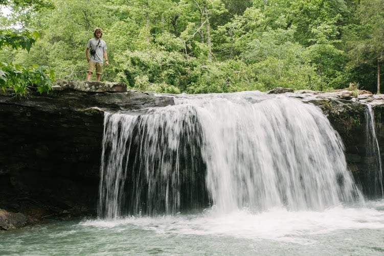
Falling Water Falls, one of several great Arkansas waterfalls not far from Fayetteville.
Photo: Andres MacLean
Last month we experienced an extraordinary amount of rain.
And although the rainy weather can be a bit inconvenient at times, anyone who has explored the Arkansas outdoors knows that the rain simply serves to fuel one of our most natural treasures – the near magical but always mystical Ozark and Ouachita waterfalls.
Below we’ve outlined nine of our favorite waterfalls this time of year – some well-known, others not.
Throw the GPS coordinates into any smartphone map app, and you’ll be on your way to fun experience.
We hope you enjoy reading about these waterfalls as much as we enjoyed traveling to them. Do your best to explore a couple while the conditions are prime!
Falling Water Falls
Location: Ozark National Forest near Witt Springs (2 hours, 22 minutes from Fayetteville)
Coordinates: N35 43.317, W92 56.964
Falling Water Falls is one of several waterfalls we visited in the Ozark National Forest.
A light stream runs above the falls, the water level of which never rises higher than the knee. The actual falls has one thick stream furthest from the road, and four smaller falls contributing to the large pool below. Multiple swings are available around this area that ideally land you in the deepest water, but use caution on these.
There are two bolted wood ladders on the far side to make access to the upper level a breeze. Several log benches behind the falls and on the outskirts of the pool provide great resting spots. The swimmable area is about 50 feet long, and 20 feet wide, but this varies with the rain and season. There is a great shaded area with smaller streams running below (some big enough to swim in) and varied rock formations. Falling Water Falls is a powerful and exciting waterfall, and is an excellent swimming hole with easy accessibility.
Photos by Andres MacLean


Lower Horsetail Falls
Location: Ozark National Forest, near Witt Springs (2 hours, 35 minutes from Fayetteville)
Coordinates: N35 45.3972, W92 56.4720
A long and narrow waterfall of about 60 feet, Horsetail Falls resides in a cozy canyon off the trail.
One can immediately sense the age of the place from the surrounding rocks that give it a great sense of grandeur.
Catching it in a wet season is pivotal, as the light stream can dry up during the summer months. It is about 30 minutes off the trail, and an ideal spot for a mid-hike, light shower, lunch spot, or just a rest.
Photos by Andres MacLean


Upper Horsetail Falls
Location: Ozark Natural Forest, near Witt Springs (2 hours, 34 minutes from Fayetteville)
Coordinates: N35 45.1524, W92 56.2890
Just up stream from Horsetail Falls, we found another waterfall.
It’s about 20-30 feet of slick rock with a narrow starting point that spreads and flows as it descends.
There is a small pool at the bottom, which leads to the downhill stream. We thought it was the oddly named Fuzzy Butt Falls initially, but these falls are actually the upper section of Horsetail Falls.
Regardless, it is an interesting area with many smaller falls around it. It’s secluded, but with several access points, and makes for a great goal for an any-day hike.
Photos by Andres MacLean


Six Finger Falls
Location: Ozark National Forest, just south of Richland Creek Campground (2 hours, 37 minutes from Fayetteville)
Coordinates: N35°45’43.0″ W92°56’15.1″
One of the most visually interesting waterfalls in the area is Six Finger Falls.
Although the drop is no greater than six feet, the manner in which they flow is simply mesmerizing. The rocks are formed in such a way that the water seems to weave down at six distinct spots, and from this the name was derived.
Below them are several areas suitable for swimming, and there is a large log bench near the center. All this culminates to create an incredibly peaceful place that is accessible to hikers of all ages.
Photos by Andres MacLean


Richland Falls
Location: Ozark Natural Forest near Richland Creek Campground (2 hours, 50 minutes from Fayetteville)
Coordinates: N35 48.349, W92 57.844
Part of the Richland Creek Wilderness, Richland Falls is set in one of the most beautiful and secluded spots on the list.
This destination is a well-known gift to travelers of the Ozark Highland Trail. It is a neighbor to many other popular falls (e.g. Twin Falls) and home to a series of often-used kayaking runs. It’s also a high-quality destination for a variety of activities, and an easy place to lose track of time.
Photos by Trent Sugg


Hemmed-in Hollow
Distance: Buffalo National Forest, near Horseshoe Bend (1 hour, 31 minutes from Fayetteville)
Coordinates: 36.07213, -93.30753
The largest waterfall not only in Arkansas, but of all that fall between the Rocky and Appalachian Mountains, is Hemmed-in Hollow. It topples over 200 feet, and is well worth the somewhat strenuous hike required.
Located on the Buffalo National River, it is a daunting plunge unlike any other in the area. The massive bluffs that serve as a background to this natural beauty are as impressive as the waterfall itself.
With all the recent waterfall, making a trip to see it in full flow is as advisable as it gets. It’s a must see for any waterfall enthusiast, and the spectacle is well worth crafting a weekend trip around it.
Photos by Ben Matthews


Triple Falls/Twin Falls
Location: Buffalo National River, near Mt. Sherman, (1 hour, 42 minutes from Fayetteville)
Coordinates: 36.05470, -93.25830
A great balance of accessibility and beauty, Triple Falls (also called Twin Falls) at their peak have three branches contributing to one small pool. They are each about 50 feet tall, but in dry seasons the three falls are whittled down to two (hence the name discrepancy).
They are very dependent on the weather in this sense, and so catching them at the right time is key. Small paths around the falls allow multiple perspectives of these beauties, and they only require a simple and short hike to reach. Ideal for a one-day trip.
Photos by Trent Suggs

Compton’s Double Falls
Location: Ozark National Forrest, near Hawks Bill Crag
Coordinates: N35 52.758, W93 27.754
Located in the the Upper Buffalo Wilderness, Compton’s Double Falls is another easily accessible waterfall in the same area as Hemmed-in Hollow and Triple Falls.
The falls were named after Dr. Neil Compton, a pivotal leader in the preservation of the Buffalo River, and founder of the Ozark Society, among extensive other work throughout Arkansas.
There are plenty of nice spots to set up for the afternoon, sink into the outdoors, and appreciate the hardwork Dr. Compton and his contemporaries did for today’s outdoor explorers.
Photos by Ben Matthews

Glory Hole
Location: Ozark National Forrest, south of Ponca (1 hour, 29 minutes from Fayetteville)
Coordinates: 35.82595, -93.39737
The most rainfall dependent waterfall on this list, catching Glory Hole at the opportune time makes for a truly special sight.
This 30-foot fall under a small cave enclosure can vary from a heavy pouring to little more than a few drops, but only requires a two-mile round-trip hike.
A natural funnel in this cavern’s ceiling creates the iconic cylinder beam where the water gushes through, but the wet rocky floor makes the viewing area somewhat precarious.
It’s only competition for oddest named waterfall is the elusive Fuzzy Butt Falls, between which no clear victor has ever emerged.
Photos by Trent Sugg and Ben Matthews


Written by brothers Devin and Brian O’Dea, travel writers and media producers for Fayettechill.