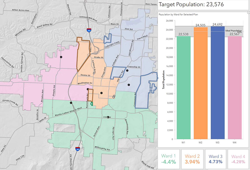
This map shows the new ward boundaries in Fayetteville. The areas that changed are highlighted above.
Click to enlarge map / Source: City of Fayetteville
FAYETTEVILLE — About 7,300 people now have new representatives on the City Council.
Council members on Tuesday voted 7-0 to approve a slightly revised ward map to better reflect the latest U.S. Census Bureau population estimates.
With a new population of 93,949, Fayetteville passed Fort Smith to become the second-largest city in the state.
Since wards 1 and 4 saw the most growth, officials proposed new ward boundaries to get the city closer to a target population of 23,576 residents for each ward.
Arkansas law requires city wards to be of substantially equal population.
“It shall be the duty of the council to see that each ward has as nearly an equal population as would best serve the interest of the people of the city,” the law states.
Under the law, any council member who remains in their old ward can keep their seat and stay in office.
The change adds some residents to Ward 2 who were previously in Ward 4, and adds some people to Ward 3 who were in Ward 1. A section of Ward 2 moved into Ward 3, and a smaller piece of Ward 2 moved into Ward 4.
Gregory Resz, the city’s GIS manager, said the new map is based solely on population numbers, and uses physical lines like streets and streams as boundaries, with some areas bounded by existing voting precincts.
The goal, Resz said, was to maintain the core of the city’s existing wards. Only five voting precincts were split, he said.
As part of the change, Ward 1 lost 1,820 residents and Ward 4 lost 3,651 residents. Ward 2 added 2,128 residents and Ward 3 gained 3,343 residents.
A map of the changes is included above for reference. City GIS staff are expected to update the official interactive online map once the ordinance goes into effect.

